
Study Area
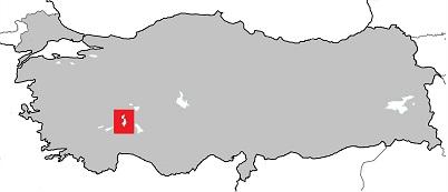
The study was conducted in Isparta province located between the Taurus Mountains and the inner-Anatolian Plateau in southwestern Turkey (Figure 1). The region consists mainly of mountanious conifer forests, dry hill sides covered by maquis vegetation, large cultivated plain lands and a few larger freshwater lakes. Some slopes and valleys also contain stands of oak forests, either former coppices, natural forests or semi-open wood pastures currently grazed by domestic animals. A total of 32 forest stands (15 oak and 17 pine) distributed across an age chronosequence ranging 185 years were chosen and surveyed for breeding birds.
Bird counts
Birds were counted using fixed-radius point taxation from four randomly distributed points in each forest stand. This technique works by counting and registering all birds seen and/or heard during a ten minute period within a radius of 50 m around the observer. Each point recieved two visits (one in the morning and in in the afternoon) within a period of seven weeks in order to cover as many resident birds as possible. Based on the observations, and accounted for imperfect detectability using the software DISTANCE, the number of occupied territories for each bird species was calculated.
Birds guilds
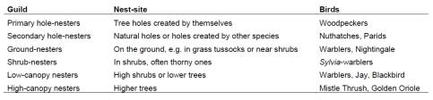
Using information obtained from Cramp et al. (1980-1994), every recorded bird species was grouped into one of six guilds (see table below) depending on their nest site preferences. After grouping, new territory densities per guild were calculated and evaluated for oak and pine stands separately.
Stand parameters
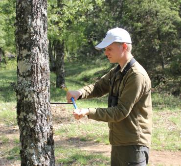
Vegetation data was sampled around two of the four points per forest stand and included: 1) Mean tree trunk circumference based on measurements of 12 randomly selected trees, 2) Mean tree trunk density calculated as the average number of tree trunks present along two fifty meter long transects extended in any of the four main compass directions, 3) The structure of two types of understory vegetation (grass and herbs, and shrubs and low trees, respectively) as percent coverage calculated from high resolute photos taken perpendicular to the ground in every main compass direction, 4) Mean stand age calculated from drill cores of trees in each stand using dendrology analyses.
|
|
|
|
|
|
Responsible for this page:
Director of undergraduate studies Biology
Last updated:
06/05/14