
Methods
Study species
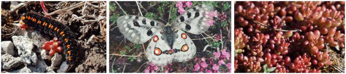
The Apollo butterfly is one of the largest butterflies in Europe with a wingspan of 73-87mm. On the IUCN Red List it is listed as vulnerable and in Sweden it is a protected species. It hibernates as an egg that hatches during spring as the temperatures get warmer. The larvae are monophagous to the host plant white stonecrop (Sedum album) on Gotland, whilst the mainland population utilises orpine (Hylotelephium telephium). After approximately one month of feeding, the larvae pupate in the first layer of the ground where it undergoes the metamorphosis into an adult butterfly. The flight season of adult butterflies spans from early June to mid-August, peaking in mid-July.
Study site
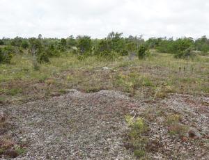
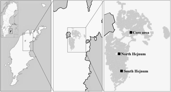
The study was conducted in the sites Filehajdar and Hejnum Hällar, close to Slite on the Swedish island of Gotland in the Baltic Sea. The biological environment is calcareous rich with a mosaic landscape of alvar, rocky grounds, forest (mainly pine trees) and wetlands. Alvar, which constitutes key habitats for the Apollo butterfly on Gotland, are calcareous rich grass plains where the soil layer is thin to non-existing, thus complicating the establishment of trees.
Within the study site, three fixed focus areas of 3x3ha each were established where surveys primarily were conducted. In Filehajdar, an area named Core Area, was placed in hectare grids with a previously recorded high abundance of adult butterflies. The additional two areas, North Hejnum and South Hejnum, were placed in Hejnum Hällar within currently grazed areas. Both latter areas also had previous recordings of adult butterflies, although not in as high abundance as in the Core Area in Filehajdar.
Data collection
Larvae & vegetation mapping

Larvae and vegetation mapping surveys were conducted simultaneously by walking along two transects per one-hectare grid cell. Transect length was 100m and widths used were 1m in the Core Area, due to the high larval abundance, and 4m in all other areas. In each hectare grid, a total of 20 circular plots measuring Ø80cm were surveyed along the transects. Within each circular plot measurements on vegetation composition, e.g. host plant cover, were collected and added to an ArcGIS map using the app Collector. The same measurements were also collected for each individual larva found within the transect and GPS positions of all larvae were added to the ArcGIS map.
Capture-mark-recapture
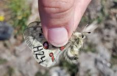
Adult butterflies were caught using a fine net whilst calmly walking in a zig-zag pattern, covering one hectare at a time. Each butterfly was individually marked with a waterproof permanent marker (Staedtler felt-tip pen) by using a letter, correlating to the observer, and number in ascending order. Further data collected were: Sex, activity (when first seen), nectar plant (if activity = feeding) and number of pollinia. GPS positions of every individual butterfly were added to an ArcGIS map using Collector.
Nectar resource mapping
Nine circular plots measuring Ø80cm were evenly distributed in each hectare grid of the three fixed focues areas, equalling 81 plots/focus area. Within the circular plots species of flowering plants were recorded. The grids were surveyed every other week, equalling a total of four visits in each focus area.
At the first survey occasion, the initial circular plot in each hectare grid was positioned by walking 25m longitudinal as well as latitudinal into the hectare grid, from one corner. The following circular plots were placed at a 25m distance from the first plot to ensure even distribution in each one-hectare grid cell. Plot positions were added to an ArcGIS map using Collector and plot locations for the following survey occasions were located using this initial map structure.
National land cover data
Besides the environmental variables recorded in field, additional environmental data was downloaded from the Swedish Environmental Protection Service. Data included: Sum of forest and open land cover, mean ground moisture index as well as mean cover and height of bushes and trees per one-hectare grid cell.
Data analysis
A binomial generalised linear model function was used to analyse larval occurrence in relation to vegetation variables and national ground cover data, where a model with as low AIC value as possible was created. When density of larvae/adult butterflies was used as dependent variable, numbers were log-transformed and a gaussian generalised linear model was used to analyse relations to vegetation variables. For variables with correlations of 0.7 or higher, the variable generating the lowest AIC was used in the final model.
Population size estimate was made using the Craig Estimator https://craigestimator.webs.com/.
For the nectar resource mapping, a chi2-test was used to analyse differences in the utilisation and abundance of nectar plants.
All data analysis was performed using R version 4.0.3.
Responsible for this page:
Director of undergraduate studies Biology
Last updated:
05/17/21